New Map Shows Which of World's Forests Stand Tallest
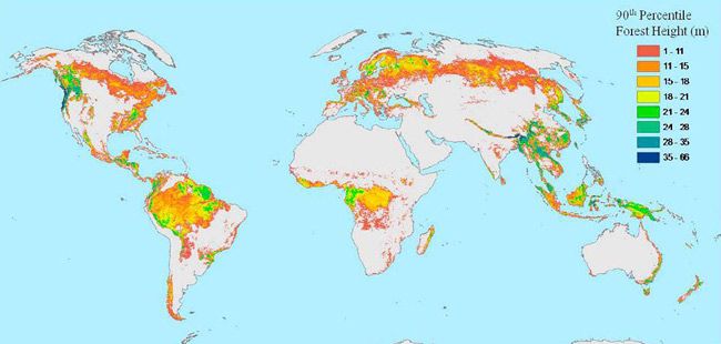
The world's tallest forests are clustered in the Pacific Northwest and portions of Southeast Asia, as shown by a first-of-its-kind map.
The map of forest heights, a work in progress that is based on data collected by NASA satellites, may help scientists measure how much carbon is stored in the world's forests and how quickly carbon cycles through ecosystems and back into the atmosphere.
The satellites found that shorter forests are located in broad swaths across northern Canada and Eurasia.
In addition to tree height, researchers analyzed the height of tree canopies — the dense, leafy covering that is the topmost layer of forests. Temperate conifer forests — which are extremely moist and contain massive trees such as Douglas fir, western hemlock, redwoods and sequoias — have the tallest canopies, soaring some 131 feet (40 meters) from the ground. In contrast, Boreal forests (those found in Arctic and sub-Arctic areas) are dominated by spruce, fir, pine and larch and typically have canopies less than 65 feet (20 m) high.
Although other local- and regional-scale forest canopy maps already exist, the new map spans the entire globe based on satellite data.
"This is a really just a first draft, and it will certainly be refined in the future," said Michael Lefsky, the scientist from Colorado State University in Fort Collins who made the map.
As the map is refined, it will help scientists estimate the amount of carbon tied up in Earth's forests and will help explain what sops up 2 billion tons of "missing" carbon each year. Humans release about 7 billion tons of carbon annually, mostly in the form of carbon dioxide. Of that, 3 billion tons end up in the atmosphere and 2 billion tons in the ocean. It's unclear where the last 2 billion tons go, though scientists suspect forests capture and store much of it as biomass (their wood and leaves) through photosynthesis.
Sign up for the Live Science daily newsletter now
Get the world’s most fascinating discoveries delivered straight to your inbox.
"What we really want is a map of above-ground biomass, and the height map helps get us there," said Richard Houghton, an expert in terrestrial ecosystem science who is deputy director at the Woods Hole Research Center in Falmouth, Mass. He was not involved in the tree-map research.
The study will be detailed in an upcoming edition of the journal Geophysical Research Letters.
- Infographic: Tallest Mountain to Deepest Ocean Trench
- Illegal Logging Down, New Report Reveals
- Amazon Storm Killed Half a Billion Trees
This article was provided by OurAmazingPlanet, a sister site to LiveScience.

