
 Live Science Plus


As Ice Recedes, U.S. Prepares For a Bustling Bering Strait

The changing Arctic climate has countries across the globe looking forward to faster, safer and more efficient sea travel across the top of the world. But newly created shipping routes could provide exactly the opposite.
With the Arctic sea ice at its lowest level in thousands of years, many shippers are eyeing the Bering Strait — between Russia and Alaska — as a new route. But just as growing numbers of cars on the road cause traffic chokepoints, more ships traversing northern passageways can choke maritime traffic.
"As Arctic sea ice recedes, economic activity in the region is going to expand dramatically," said Sen. Mark Begich, D-Alaska.
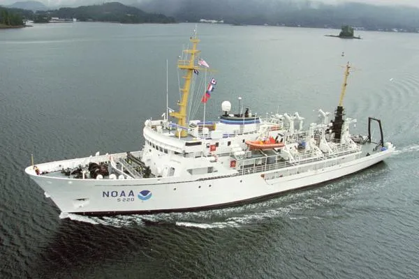
In anticipation of increased traffic, the U.S. National Oceanic and Atmospheric Administration has dispatched its ship Fairweather to detect navigational dangers in critical Arctic waters that have not been charted for more than 50 years.
"We have seen a substantial increase in activity in the region, and ships are operating with woefully outdated charts," said Sen. Lisa Murkowski, R-Alaska. "I have introduced legislation that authorizes a significant increase in funding for mapping the Arctic, and I am pleased to see NOAA beginning the process.
"While this is a good start, we still need more resources to adequately map this region."
The Fairweather, based in Ketchikan, Alaska, is spending July and August measuring ocean depths, examining seafloor features and supplying data to update NOAA charts spanning 350 square nautical miles (1,200 square kilometers) of the Bering Strait around Cape Prince of Wales. (A nautical mile corresponds to about one minute of arc of latitude, or about 1.15 miles.)
The data also will support scientific research on important fish habitats, provide new tidal information and help accommodate the expected flood of leisure activities in the area.
"Commercial shippers aren't the only ones needing assurances of safety in new trade routes," said Capt. John Lowell, director of NOAA's Office of Coast Survey. "The additional potential for passenger cruises, commercial fishing and other economic activities add to pressures for adequate response to navigational risks."
About a third of U.S. Arctic waters are deemed "navigationally significant." Of that area, NOAA's Office of Coast Survey has identified 38,000 square nautical miles (131,000 square km) as survey priorities. NOAA says mapping the prioritized areas of the Arctic seafloor will take more than 25 years.
"President Thomas Jefferson ordered a survey of the East Coast in 1807, when our country was losing more ships to unsafe navigation than to war. Today we have better maps of the moon than of our own oceans," said Capt. David Neander, commanding officer of the Fairweather. "Our 46-person crew is amassing ocean data that directly affects our economy and our ecosystems."
- 8 of the World's Most Endangered Places
- Glacier Once Stuck to Sea Floor, Breaks Loose
- Greenland Rising Rapidly As Ice Melts
This article was provided by OurAmazingPlanet, a sister site to LiveScience.
Get the world’s most fascinating discoveries delivered straight to your inbox.
