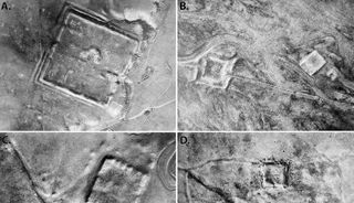
Cold War satellite images reveal nearly 400 Roman forts in the Middle East
The photos, taken in the 1960s and 1970s by the first spy satellites, reveal that the eastern border of the Roman Empire was a place of vibrant trade.

Declassified images from Cold War spy satellites have revealed hundreds of previously undiscovered Roman forts in Iraq and Syria — and their existence suggests the eastern border of the ancient empire wasn't as violent as initially thought, a new study finds.
Researchers already knew about a series of forts — spanning roughly 116,000 square miles (300,000 square kilometers) from the Tigris River in modern-day Iraq to the plains of the Euphrates River in Syria — that were once thought to belong to a north-south border wall that separated the Romans from the rival empire of Persia.
But the distribution, from east to west, of the newfound forts along with those previously known ones, hints that they were built to facilitate peaceful trade and travel. The new study, published Thursday (Oct. 26) in the journal Antiquity, refutes a 1934 hypothesis by the French archaeologist and Jesuit priest Antoine Poidebard that the eastern fortifications were built to repel invaders.
Related: Ruins of ancient Roman emperor Nero's theater unearthed in 'exceptional' discovery in Rome
"Since the 1930s, historians and archaeologists have debated the strategic or political purpose of this system of fortifications," lead study author Jesse Casana, a professor of anthropology at Dartmouth College, said in a statement. "But few scholars have questioned Poidebard's basic observation that there was a line of forts defining the eastern Roman frontier."
Stretching across the deserts of Iraq and Syria, Poidebard discovered 116 of the second and third century A.D. forts after taking aerial photographs in the 1920s and 1930s. Looking at their placement from his biplane, which he learned to fly during World War I, Poidebard hypothesized that the square-shaped strongholds created a north-south defensive line that drove back raids from Parthians and later the Sassanid Persians.
Until now, Poidecard's hypothesis was widely accepted by historians. But after analyzing high-resolution images of the region taken by spy satellites in the 1960s and 1970s, the researchers discovered 396 previously unknown forts or fort-like buildings that were sprinkled widely from east to west.
Sign up for the Live Science daily newsletter now
Get the world’s most fascinating discoveries delivered straight to your inbox.
This suggests the border was more fluid than first thought, with the outposts existing not along the border but through it — protecting trade caravans as they ferried people and goods between Rome and the neighboring Parthian (later Sassanid Persian) Empire. The archaeologists say this raises an important question about the border: "Was it a wall or a road?"
The researchers say their study highlights the importance of declassified images in archaeological research — especially as many of the forts revealed in the photos have now been destroyed by agricultural expansion and urbanization. They expect more discoveries to accompany the declassification of other aerial images, such as those taken by U2 spy planes.
"Careful analysis of these powerful data holds enormous potential for future discoveries in the Near East and beyond," Casana said.

Ben Turner is a U.K. based staff writer at Live Science. He covers physics and astronomy, among other topics like tech and climate change. He graduated from University College London with a degree in particle physics before training as a journalist. When he's not writing, Ben enjoys reading literature, playing the guitar and embarrassing himself with chess.