California's fast-moving Creek Fire spawns 'fire cloud' visible from space
Fires continue to ravage California, with five new blazes igniting since Friday (Sept. 4).
The worst of those fires started on Friday and has already covered more than 75,000 acres (300 square kilometers). Called the Creek Fire, it has likely spawned fire tornadoes and forced the California Air National Guard to rescue more than 200 people trapped by the flames, according to the Washington Post.
Related: California wildfire damage spotted from space (photos)
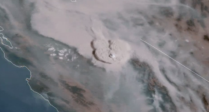
The Creek Fire also created a staggering "fire cloud" that a National Oceanic and Atmospheric Administration (NOAA) satellite could see from space.
"@NOAA's #GOES17 has been monitoring California's #CreekFire, which grew explosively today after igniting in the Sierra National Forest on Friday," NOAA's public affairs office wrote on Twitter on Sunday (Sept. 6). "In this loop, you can see the fire's extraordinary #Pyrocumulonimbus cloud, which reached an estimated 45,000+ ft [14,000 meters, or about 8.5 miles] high."
A pyrocumulonimbus cloud is basically a thunder cloud triggered by the heat and moisture that a fire kicks into the atmosphere, according to NASA. Such structures can also send huge amounts of pollutants into the upper atmosphere, according to NASA.
UPDATE: @NOAA's #GOES17🛰️ has been monitoring California's #CreekFire, which grew explosively today after igniting in the Sierra National Forest on Friday. In this loop, you can see the fire's extraordinary #Pyrocumulonimbus cloud, which reached an estimated 45,000+ ft high. pic.twitter.com/pcWwnrA2zsSeptember 6, 2020
This GOES-17 Natural Color Fire RGB satellite imagery shows the explosive growth on Saturday of the latest in a series of terrible fires to impact California this season. This new fire called the Creek Fire is located in Fresno County and has grown to over 36,000 acres in size. pic.twitter.com/a5PZiC4hbqSeptember 6, 2020
A second NOAA Twitter account shared additional imagery from the same GOES-17 satellite, which shows the spread of the Creek Fire. GOES-17 has monitored weather in the Western U.S. since its launch in 2018.
Sign up for the Live Science daily newsletter now
Get the world’s most fascinating discoveries delivered straight to your inbox.
Most recently, the same satellite spotted smoke billowing across nearly all of California and Nevada in the evening of Monday (Sept. 7), according to a NOAA tweet. According to California's fire agency, the five fires sparked since Friday have burned more than 100,000 acres (400 square kilometers).
On this #MondayMorning, look at a Labor Day p.m. capture of the #California fires by @NOAA's #GOESWest. As of late last night, the Creek, Valley, and Oak fires were under 5% containment. Strong winds with gusts of 40-50 mph are forecast today, possibly fanning the flames. pic.twitter.com/OtvFf85JRSSeptember 8, 2020
Email Meghan Bartels at mbartels@space.com or follow her on Twitter @meghanbartels. Follow us on Twitter @Spacedotcom and on Facebook.
Meghan is a senior writer at Space.com and has more than five years' experience as a science journalist based in New York City. She joined Space.com in July 2018, with previous writing published in outlets including Newsweek and Audubon. Meghan earned an MA in science journalism from New York University and a BA in classics from Georgetown University, and in her free time she enjoys reading and visiting museums. Follow her on Twitter at @meghanbartels.


