Earth from space: The heart-shaped 'Spirit Lake' sculpted by Mount St. Helens' epic eruption
This 2023 satellite photo shows the heart-shaped Spirit Lake, which was transformed by the cataclysmic eruption of Mount St. Helens in 1980.
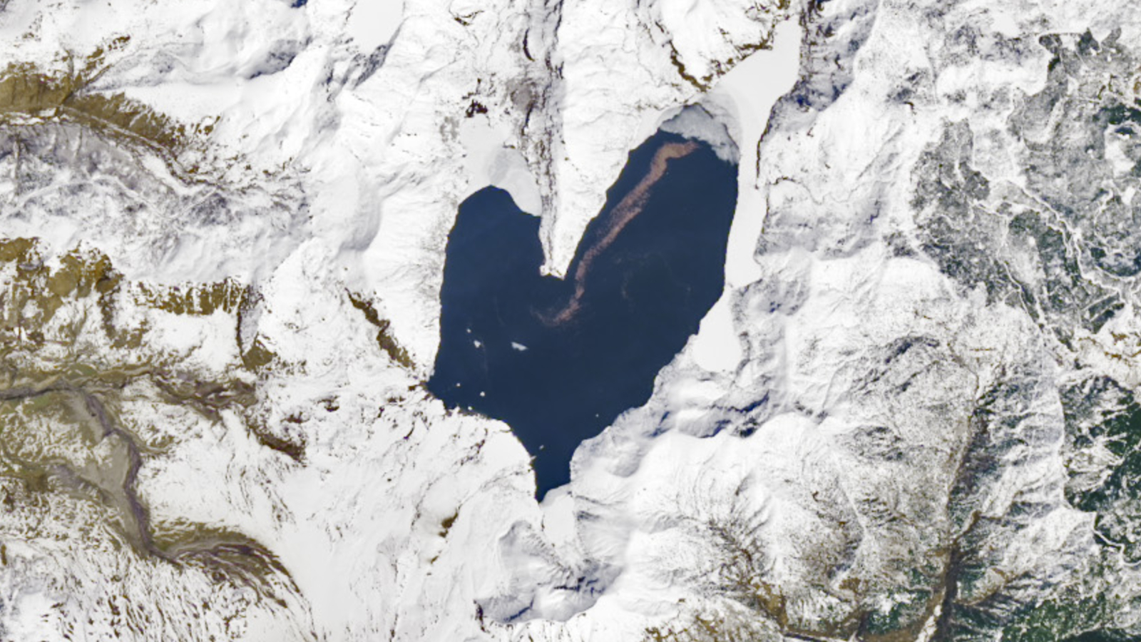
Where is it? Spirit Lake, Washington [46.2658524, -122.1512829]
What's in the photo? A heart-shaped lake next to Mount St. Helens.
Which satellite took the photo? Landsat 8
When was it taken? April 26, 2023
This striking satellite photo shows the unusual shape of Spirit Lake, which was transformed into a giant anatomically inaccurate heart by the explosive eruption of Mount St. Helens in 1980. Today, the resilient body of water is closely monitored by scientists who are studying how ecosystems can rebound after major natural disasters.
At approximately 8:32 a.m. PDT (11:32 a.m. EDT) on May 18, 1980, a 5.1 magnitude earthquake triggered a "cataclysmic eruption" at Mount St. Helens — an active stratovolcano around 90 miles (150 kilometers) south of Seattle in Washington state, according to the U.S. Geological Survey. At first, the summit and northern slope of the mountain subsided, creating the biggest subaerial (on land) landslide in recorded history. Then, an enormous explosion released a giant pyroclastic plume into the sky and rained rocks, lava and ash across the surrounding area.
Fifty-seven people were killed by the initial landslide and fallout, making it the deadliest volcanic eruption in U.S. history. It also caused around $1 billion in damages (equivalent to around $3.8 billion today).
Prior to the eruption, Spirit Lake "had a smaller footprint that consisted of west and east arms connected by a narrow span of water — similar in shape to the top half of a heart," according to NASA's Earth Observatory.
However, the landslide and resulting blast reshaped the lake, making it broader and shallower — and completing the heart shape. The lake's surface, which now covers around 4.5 square miles (11.5 square km), is also around 200 feet (60 meters) higher than it used to be.
Related: See all the best images of Earth from space
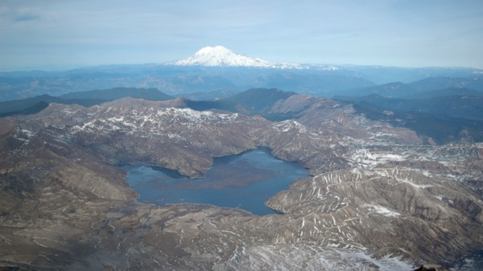
Spirit Lake was once a popular tourist destination with six different camps and many log cabins scattered along its edge (the remains of which are now likely buried beneath the lake).
Sign up for the Live Science daily newsletter now
Get the world’s most fascinating discoveries delivered straight to your inbox.
However, despite recovering from the eruption, the lake remains largely off-limits to people and there are now bans on fishing and swimming in its waters. This is because scientists want to study exactly how the lake's ecosystem has rebounded from the disaster, according to Earth Observatory.
Researchers are particularly interested in a raft of trees on the lake's surface (visible as a brown streak in the satellite image), which were uprooted during the eruption and have now likely "become an important part of the lake’s ecosystem."
An explosive rebirth
During the eruption, the landslide displaced most of the water in Spirit Lake, creating a wave up to 800 feet (250 m) tall that washed over the lake's shoreline, according to American Scientist. The water eventually flowed back into the basin and settled on top of the volcanic debris.
However, lava from the eruption had blocked the lake's natural outflow, which previously fed into the North Fork Toutle River. As a result, the lake's surface continued to rise until 1985, when engineers constructed a new 8,500-foot-long (2,500 m) drainage tunnel to stop it overfilling. Without this tunnel, the volcanic dam may have eventually burst and triggered devastating floods in the river's valley.
In the early months after the eruption, up to 40% of the lake's surface was covered by uprooted trees. This, along with volcanic gases seeping up from the lakebed, had made the water anoxic, or devoid of oxygen, making it inhospitable to life.
Scientists initially predicted it could take decades before life returned to the lake. But in 1983, scientists detected phytoplankton growing on the lake's surface, which slowly returned oxygen to the water and kickstarted the recovery process, which is now in full swing.

Harry is a U.K.-based senior staff writer at Live Science. He studied marine biology at the University of Exeter before training to become a journalist. He covers a wide range of topics including space exploration, planetary science, space weather, climate change, animal behavior and paleontology. His recent work on the solar maximum won "best space submission" at the 2024 Aerospace Media Awards and was shortlisted in the "top scoop" category at the NCTJ Awards for Excellence in 2023. He also writes Live Science's weekly Earth from space series.
You must confirm your public display name before commenting
Please logout and then login again, you will then be prompted to enter your display name.

