'Unusual' and weak La Niña finally here, NOAA confirms
NOAA has declared that a La Niña is underway. This cool weather event is likely to be shorter and weaker than usual, but will still affect global weather and climate.

Officials have announced that an "unusual" La Niña weather pattern (that was supposed to start last summer) is finally underway. However, it is expected to be weaker and shorter than usual.
La Niña is the cold phase of a natural climate pattern called the El Niño Southern Oscillation (ENSO) cycle, which is a pattern of atmospheric and sea temperature changes in the tropical Pacific Ocean that affects global weather and climate.
During a La Niña event, the northern U.S. and Canada typically experience colder and wetter winters, while the southern U.S. becomes warmer and drier, according to the National Oceanic and Atmospheric Administration (NOAA) . La Niña also tends to increase hurricane activity over the Atlantic.
However, the current La Niña arrived later than expected and didn't have time to gain strength before winter started. The conditions for this "unusual" La Niña appeared in December and are likely to persist through to April, NOAA said in a statement on Thursday (Jan. 9).
"We've been expecting La Niña to show up since last spring," NOAA representatives wrote. "While she's dragged her heels, all the pieces came together this past month."
ENSO is a multi-year cycle that triggers a warm El Niño and then a cold La Niña every two to seven years. These events then usually last up to a year each. An El Niño contributed to record-breaking heat in 2023 and 2024, so researchers expected the La Niña to follow. Researchers aren't sure why this La Niña was slow to develop, but warmer-than-average ocean temperatures in 2024 might have played a role, according to NOAA.
Sign up for the Live Science daily newsletter now
Get the world’s most fascinating discoveries delivered straight to your inbox.
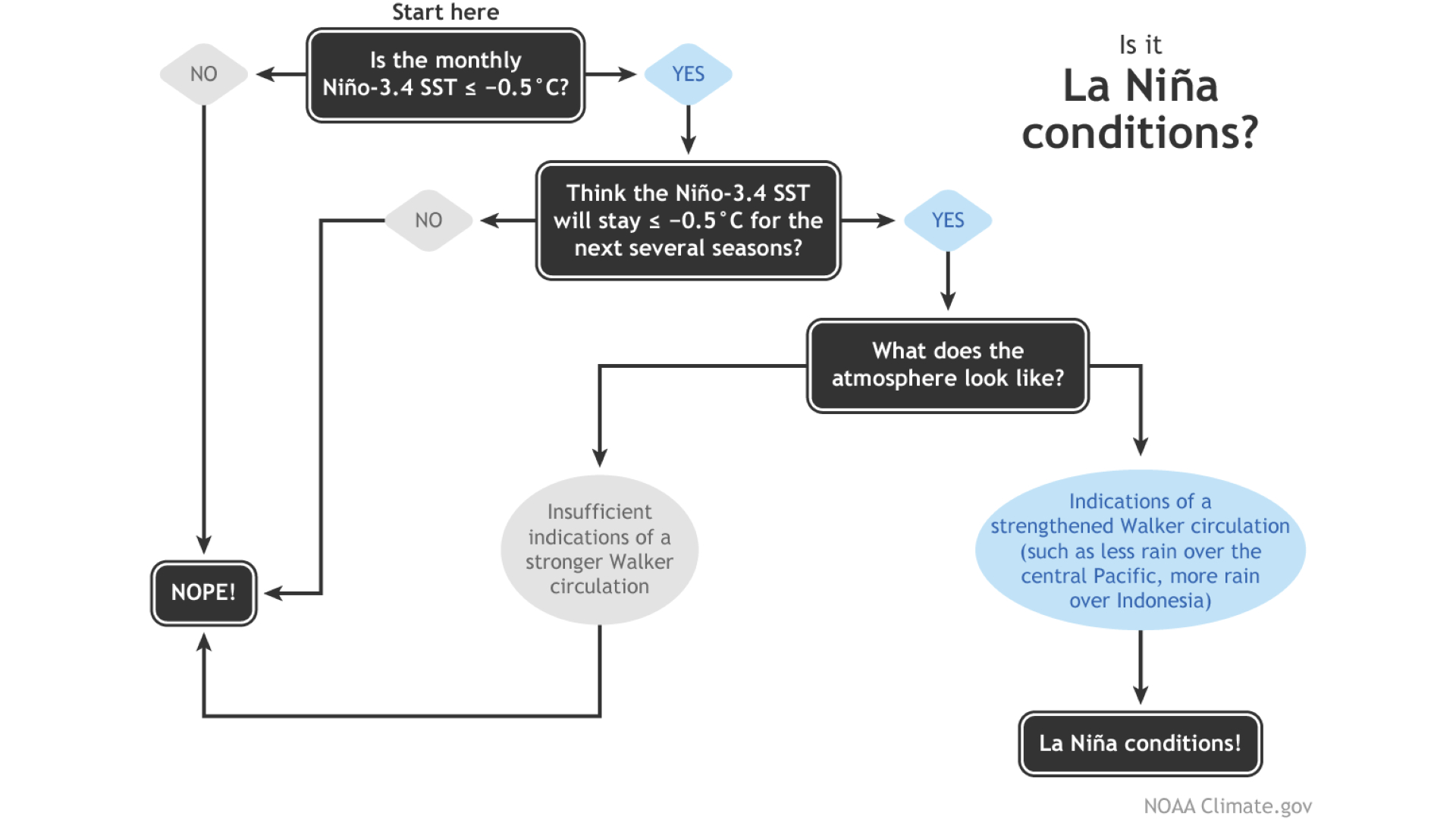
La Niña flowchart

NOAA has a flowchart for determining when a La Niña is officially underway. Firstly, tropical Pacific sea-surface temperatures must fall 0.9 degrees Fahrenheit (0.5 degrees Celsius) below the long-term average.
Sea surface temperatures have been within 0.9 degrees F of the average since April, but finally went below the threshold for La Niña in December. NOAA computer models predict that the temperatures will stay below the threshold until spring.
"There's a 59% chance La Niña will persist through February–April, followed by a 60% chance of neutral conditions in March–May," the NOAA representatives wrote.
The temperatures must remain below the threshold for five consecutive seasons — any three-month period — for this La Niña to make it into the NOAA's official historical record, which won't happen if the La Niña fizzles out by March to May. However, ENSO events are notoriously difficult to predict.
Scientists will continue to monitor the tropical Pacific sea-surface temperatures to see how long the La Niña lasts, and investigate the drivers behind this potentially shorter and weaker ENSO event.
"There's a reason our flowchart says 'the next several seasons' instead of providing a specific number: we can make predictions, but it's impossible to know ahead of time exactly how long La Niña conditions will last," NOAA representatives wrote.

Patrick Pester is the trending news writer at Live Science. His work has appeared on other science websites, such as BBC Science Focus and Scientific American. Patrick retrained as a journalist after spending his early career working in zoos and wildlife conservation. He was awarded the Master's Excellence Scholarship to study at Cardiff University where he completed a master's degree in international journalism. He also has a second master's degree in biodiversity, evolution and conservation in action from Middlesex University London. When he isn't writing news, Patrick investigates the sale of human remains.


