
The U.S. is experiencing record-breaking cold and heavy snow this week as another winter storm sweeps across several central and eastern states.
Wind chills between minus 30 and minus 60 degrees Fahrenheit (minus 34 and 51 degrees Celsius) have been forecast for the northern Plains over the next few days, and below-zero wind chills will likely reach as far south as southern Texas, Arkansas, western Tennessee and Kentucky, the National Weather Service (NWS) said in a post on Facebook.
"An Arctic air mass is expected to plunge into the Central U.S. this week, with high confidence for widespread, record-breaking cold," NWS said in the forecast. "Through Friday [Feb. 21], numerous daily records are likely to be broken across the Plains and Lower Mississippi Valley with some locations experiencing their coldest temperatures on record for so late in the season."
The storm is bringing heavy snowfall to millions of Americans as it passes through the Midwest toward the mid-Atlantic, with some areas set to receive up to 1 foot (31 centimeters) of snow through Thursday [Feb. 20], according to a statement released by the weather website AccuWeather.
"Much of Virginia and North Carolina are going to be an absolute mess with snow and dangerous ice," Bernie Rayno, chief on-air meteorologist at AccuWeather, said in the statement.
Snow is also forecast for Kentucky, which has been experiencing deadly flooding since the weekend. The latest storm is the last in a back-to-back "February frenzy" of winter storms, according to AccuWeather.
Related: 'We are creating the fire equivalent of an ice age': Humans have plunged Earth into the 'Pyrocene'
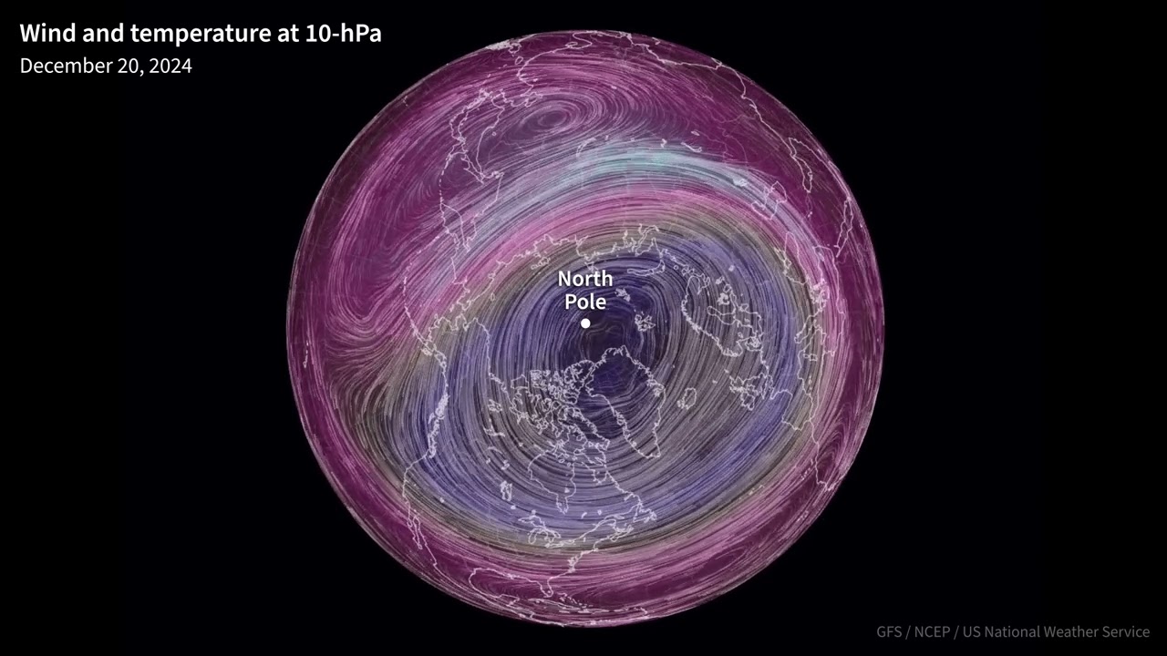
Some media coverage has linked the latest blast of cold weather to the polar vortex — an area of low pressure and cold air circulating around the North and South poles in the stratosphere, which is a layer in the atmosphere between 7.5 and 31 miles (12 and 50 kilometers) above Earth's surface. However, it is unclear whether the polar vortex has actually played a significant role.
Paul Pastelok, the lead long-range forecaster at AccuWeather, told Live Science in an email that a blocking pattern —area of high pressure — over northern Canada was the main driver forcing cold air to sink south into the central Plains and mid-Mississippi Valley. This cold air then clashed with warmer temperatures further south to create storms.
"The February frenzy was driven by a sharp contrast of warmer temperatures along the Gulf Coast and colder air across the northern Rockies, northern Plains and Canada," Pastelok said. "In between this sharp contrast, there was a zone of stormy weather dividing the two airmasses that has led to this frenzy."
What is the polar vortex?
Polar vortices exist throughout the year at the poles. In the Northern Hemisphere, the polar vortex expands many times over the winter, pushing cold air south with the jet stream. This expansion is often associated with the arrival of Arctic air in the contiguous U.S., according to the NWS.
This winter, the vortex appears to have been strong and stable for the most part, according to NOAA's Polar Vortex Blog — a strong polar vortex like this would usually keep cold Arctic air away from the U.S.
"Generally when the polar vortex is strong, this means it's mainly centered over or near the pole with strong westerly winds wrapping around its tight center, holding intense cold around the upper latitudes and upper levels of the atmosphere," Pastelok said.
Last week, warming temperatures in the stratosphere lessened the westerly winds and weakened the vortex so it was slightly displaced from the North Pole. That enabled some cold to make its way further south, but mostly to Asia and Europe, according to Pastelok.
"This weakening of the vortex and movement could have had some contribution [to] the shift farther south of the polar Jet stream across southern Canada, and the cold that is impacting the U.S. this week and next week," Pastelok said.
Is the polar vortex responsible for the winter storm?
Amy Butler, a research scientist who studies the climate at National Oceanic and Atmospheric Administration's (NOAA) Chemical Sciences Laboratory, said that the role of the polar vortex in February's cold weather is somewhat unclear. The polar vortex is very strong but also currently stretched over North America.
"Some research suggests that this [stretching] is associated with increased cold air outbreaks over the central and eastern US; however, the causality is not clear," Butler told Live Science in an email. "It might be that the vortex is simply responding to the region of high pressure over the Arctic — the high pressure could essentially be stretching the lowermost vortex apart."
Butler thinks the high pressure in the Arctic — part of a shifting of atmospheric pressure called the Arctic Oscillation — is most likely responsible for the cold weather in the central U.S.
"This region of high pressure over the Arctic represents a build up of air mass that helps to shift the jet stream to the south and allows cold Arctic air to spill southward," Butler said.
Why have there been so many polar vortex events?
The Associated Press (AP) reported on Feb. 14 that the polar vortex had stretched for the 10th time this winter. Laura Ciasto, a meteorologist at NOAA's Climate Prediction Center, told AP that meteorologists will want to study why this stretching is happening so often this year but noted that it could just be natural randomness.
Ciasto and Butler write NOAA's Polar Vortex Blog, where they often explain that cold weather has nothing to do with the polar vortex. Butler told Live Science that she thinks there have not been many, if any, truly polar vortex-driven events this winter.
"We traditionally think of a polar vortex 'event' as when the vortex is disrupted or slows down rapidly, and the vortex instead has been very strong all winter," Butler said.
Is climate change altering the polar vortex?
The jury is still out on whether humans are altering the polar vortex through climate change. Global temperatures are warming around four times faster in the Arctic than in the rest of the world. This Arctic amplification happens because ice reflects more sunlight than land or water. As Arctic sea ice melts, the region absorbs more sunlight and warms up faster than non-ice regions, according to the International Science Council.
Some studies suggest that Arctic warming might be disrupting the polar vortex. For example, a 2021 study published in the journal Science found that Arctic amplification was likely an important factor in polar vortex stretching events that brought extreme cold to North America in 2021.

You must confirm your public display name before commenting
Please logout and then login again, you will then be prompted to enter your display name.


