Laura expected to slam into Texas and Louisiana as a Category 3 hurricane
This is a serious storm, threatening Texas and Louisiana.

Tropical storm Laura is now a hurricane, and it's expected to grow even more powerful as it whirls toward Louisiana and Texas.
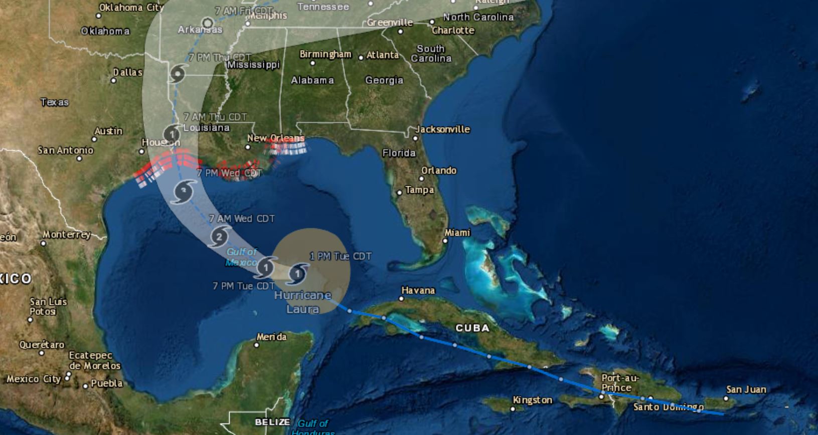
The storm passed over Cuba and into the Gulf of Mexico Tuesday morning (Aug. 25), strengthening into a hurricane even as the scattered remains of tropical storm Marco drifted away from the site of their Louisiana landfall. Laura is expected to pick up energy from the warm gulf waters in the next couple days, then make landfall as a Category 3 "major hurricane" — 2020's first — with wind speeds of at least 111 mph (178 km/h), according to the National Hurricane Center (NHC).
As with most tropical cyclones, the most significant threat from Laura is flooding, not wind. Already, as a tropical storm, it has killed 13 people on the island of Hispaniola. Eleven of those who died were in Haiti and two in the Dominican Republic, according to The Weather Channel. Haitian authorities posted this video of the flooding:
#TTLaura: Anpil lapli gentan tonbe plizyè kote nan peyi, sitou nan Lwès ak nan Sidès. Sonje : dlo k ap desann PA JWE‼️#SezonSiklòn2020 #Laura pic.twitter.com/y5MlBEFWL8August 23, 2020
In Puerto Rico, El Nuevo Dia reported that two teenagers spent all night on a rock in the middle of the Toro Negro River, in Ciales, while rescue teams tried to reach them through the floodwaters. The 19-year-old and 17-year-old arrived at the popular El Morón pool in the river, seeing sunny skies despite the storm warnings. They became stuck as Laura dumped water into the river, and remained trapped as the floodwaters and storm conditions thwarted multiple rescue attempts. By early morning, the water levels subsided enough for rescuers to reach them.
Related: Hurricane season: How long it lasts and what to expect
When Laura hits the U.S. coast Thursday morning (Aug. 27), it will push an even stronger storm surge ahead of it and dump much more rain than Marco. According to the NHC, the storm surge between High Island, Texas and Morgan City, Louisiana could reach 7 to 11 feet (2.1 to 3.4 meters). Four to 6 feet (1.2 to 1.8 m) are possible across an even wider area, between Port Bolivar, Texas (just east of Galveston) and the mouth of the Mississippi River, just west of New Orleans. Storm surges of at least 2 feet up to 4 feet (0.6 to 1.2 m) are expected all the way from San Luis Pass, Texas (south of Houston) to Ocean Springs, Mississippi, a span of 388 miles (625 kilometers).
Sign up for the Live Science daily newsletter now
Get the world’s most fascinating discoveries delivered straight to your inbox.
These details could change as the hurricane approaches land, but time to prepare is limited. Tropical storm-force winds, meaning winds of 39-73 mph (63–118 km/h), could arrive in the area as early as Wednesday afternoon (Aug. 26), according to the NHC.
Louisiana and Texas have both issued evacuation orders along their coasts. That means that six states have ordered natural disaster evacuations this month, with people in California, Oregon, Washington and Colorado having to flee severe wildfires. As Live Science previously reported, evacuations during a global pandemic can add another layer of complexity to an already fraught situation. Evacuations will potentially contribute to the new coronavirus's spread, as people who would otherwise shelter in place congregate with others, according to research from Columbia University.
Wildfires, major hurricanes and global pandemics are all becoming more severe threats due to climate change, several studies have shown.
What's more, Laura is a record-setting in its own right; the storm system is the earliest 13th tropical cyclone of any year on the books, as meteorologist Matt Lanza noted.
The 2020 season has set the record for the earliest C, E, F, G, H, I, J, and K storms. Go ahead and snipe about some of these storms being subpar or maybe not named in the pre-satellite era, but whatever the case...we're beating 2005 in quantity (not quality).August 14, 2020
Eight other storms this year have set similar records, making 2020 already one of the busiest tropical cyclone seasons ever.
Originally published on Live Science.


